


 On eBay Now...
WWII U.S. Invasion of Germany Map Encirclement of the Ruhr Operations Relic For Sale

When you click on links to various merchants on this site and make a purchase, this can result in this site earning a commission. Affiliate programs and affiliations include, but are not limited to, the eBay Partner Network.

WWII U.S. Invasion of Germany Map Encirclement of the Ruhr Operations Relic:
$106.25
This WWII U.S.infantry map was brought backby a U.S. veteran who saw combat in theEuropean theater of operation against the Germans.What makes this map interesting is the cuts and glue marks located around all four edges. This map at one point was used as a large intelligence and troop movement map for the Western Allied invasion of Germany, coordinated by the Western Allies during the final months of hostilities in the European theatre of World War II. In preparation for the Allied invasion of Germany, a series of offensive operations were designed to seize and capture the east and west bank of the Rhine River: Operation Veritable and Operation Grenade in February 1945, and Operation Lumberjack and Operation Undertone in March 1945. The Allied invasion of Germany started with the Western Allies crossing the Rhine on 22 March 1945 before fanning out and overrunning all of western Germany from the Baltic in the north to the Alpine passes in the south, where they linked up with troops of the U.S. Fifth Army in Italy. Combined with the capture of Berchtesgaden, any hope of Nazi leadership continuing to wage war from a so-called "National redoubt" or escape through the Alps was crushed, shortly followed by unconditional German surrender on 8 May 1945. This is known as the Central Europe campaign in United States military histories.
While there is no title on this map, or date because of its unique usage, it is very similar to other U.S. and Allied infantry maps dated 1944 and 1945. This map shows heavy usage, and at one point was a part of a larger map face the E.T.O. and depicts infamous towns such as Lippstadt, Salzkotten, Buren, Brilon, etc. The town of Lippstadt as featured on this map is noted as a town located near the infamous battles and “Encirclement of the Ruhr”. The Ruhr Pocket was a battle of encirclement that took place in April 1945, on the Western Front near the end of the second World War, in the Ruhr Area of Germany. Some 317,000 German troops were taken prisoner along with 24 generals. The Americans suffered 10,000 casualties including 2,000 killed or missing.
Related Items: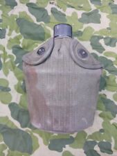
WWII U.S. 1945 DATED CANTEEN WITH COVER AND CUP
$35.00

( 1 ) WWII US Army Military EE-8 Field Phone Handsets, New Cord, Tested Working
$64.60
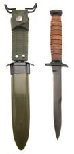
U.S. WWII M3 Fighting Knife with Scabbard
$39.99